
2025-10-28 / UCAC4 330-205982 / (226) Weringia
| # | OBS | Observer | Occ | Meth. | Instr. | CC | TSRC | UT1 | UT2 | UT3 | UT4 | UT2E | UT3E | Dur. | Chrd |
|---|---|---|---|---|---|---|---|---|---|---|---|---|---|---|---|
| 1 | show | Carles Schnabel | O+ | VID | M400 | ES | GPS | 20:31:43 | 20:33:32.86 | 20:33:35.11 | 20:35:34 | 0.070 | 0.150 | 2.25 | 24.3 |
| 2 | show | Jorge JUAN, Carles Schnabel | O+ | VID | M410 | ES | GPS | 20:30:13 | 20:33:32.37 | 20:33:34.13 | 20:35:08 | 0.160 | 0.160 | 1.76 | 19.0 |
| 3 | show | Martin Gutekunst | O+ | VID | L280 | DE | GPS | 20:33:20 | 20:34:21.041 | 20:34:22.531 | 20:35:20 | 0.068 | 0.068 | 1.49 | 16.1 |
3 observations found in db: sodis
Available (probably) matching predictions (click on the link to switch):
| JPL#77 : 331d0630-ddb3-11f0-547e-c571fff27b7f [db: observed] |
| JPL#77 : a57f26e0-ddb8-11f0-547e-a3925f9daed6 [db: observed] |
| Using prediction a57f26e0-ddb8-11f0-547e-a3925f9daed6 for map and profile fit |
| Ellipse and circular profile fits to the timings (chords) |
|---|

|
Auto-Fit Result: Size = 121 x 6 km a',b' = 60.6, 3.2 km X0,Y0 = 1375.6, 24.1 km Mean diameter = 28 km From 3 chords (VID) You can enter space separated chord numbers (example: 11 4 8) or a method like VIS to ignore all visual timings, or a time source like RAD and NTP (but not GPS). If the plot disappears, then there are less than 2 chords left (too much ignored, go back with browser). Check SiMDA for size and mass data. Check Johnston Archive for satellites. |
Sky projection (artificial light) for occ. time: 2025-10-28, 20:33 UT (JD = 2460977.356)
| DAMIT | Q | P (h) | λ, β | JD0 | JD-JD0 | φ0 | Version | Modified | Vol-equiv D | Cmnt |
|---|---|---|---|---|---|---|---|---|---|---|
| # 1074 | None | 11.148 | 284°, -14° | 2.444424e6 | 16553.4 | 0.0° | None | None | not scaled | 2016-01-04 |
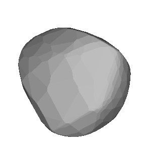
Image size: 300px. Transparent image background for copy & paste
| Map with groundtrack and observer stations |
|---|
| Event Details |
|---|
| More Data and Informations |
|---|
(If error 404: link not valid which means no data available)
| Aladin Sky Atlas |
|---|
Loading sky atlas…
Aladin Lite direct link (has Gaia overlay)